
The winter episode that began on Wednesday will harden with a new mass of cold air that will cause cold and unpleasant weather this weekend, although not equally in all parts of the Peninsula and the Balearic Islands.
According to the State Meteorological Agency, night temperatures may drop to 10 degrees below zero in some parts of Castilla y León.
On Saturday snowfall is expected in the northwest of the country, in Extremadura and the west of Castilla-La Mancha and in the east of Andalusia.
But it is on Sunday, when the entry of a new arctic air mass is expected, when the temperatures will drop sharply.
That day it is expected that it will snow at low levels throughout the north of the Peninsula, although not too strongly.
Locally heavy rainfall is expected in the Strait area.
Frost is forecast for Saturday in mountainous areas, which will spread to much of the interior on Sunday.
Strong frosts are expected in the Pyrenees.
The wind will pick up on Sunday in the Ampurdán, the Pyrenean region and the Ebro valley.
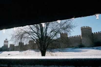
Snowy landscape next to the wall of Ávila early this Friday morning.
RAUL SANCHIDRIÁN (EFE)
A man was walking through a snow-covered park in Vitoria on Thursday. David Aguilar (EFE)
View of the waves early this Friday at the Peine del Viento in San Sebastián (Gipuzkoa). Javier Etxezarreta (EFE)
Snowy mountains this Friday in the vicinity of Bilbao. LUIS TEJIDO (EFE)
A frost-covered swing early this Friday morning in Ávila.
RAUL SANCHIDRIÁN (EFE)
Some horses tried to protect themselves from the snow on Thursday in Campoo de Yuso, Cantabria.
Pedro Puente Hoyos (EFE)
View of the snow-capped Peñas de Aia mountains this Friday early in San Sebastián (Gizpukoa). Javier Etxezarreta (EFE)
View of the Sierra de Aralar (Navarra), on Thursday. Villar López (EFE)
In the Canary Islands, there will be weak and occasional rainfall throughout the weekend in the larger islands.
Temperatures will experience little change until Sunday, when they are expected to rise.
Notable drops in temperature are expected on Monday in large areas of the Peninsula and the Balearic Islands, which will continue on Tuesday, although less pronounced.
There will be widespread frosts on the Peninsula, except in the coastal areas and in the extreme southwest.
In the northern half of the peninsula, as well as in the Andalusian mountain ranges, these frosts will be more intense, and stronger in the Iberian system and the Pyrenees.
The maximum temperatures will also be very low and will not exceed five degrees in large areas of the northern half.
The wind will be predominantly from the north and northwest, more intense in the northeast quadrant of the peninsula and the Balearic Islands, where very strong gusts could be reached, which will cause an additional decrease in thermal sensation.
This wind will gradually lose intensity on Tuesday and Wednesday, except in the Balearic Islands, where it could continue to affect the north of Mallorca and Menorca.

