
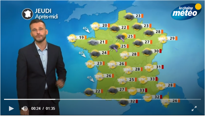
Thunderstorms return to shake the sky this Thursday, says the Weather Channel. They erupt between the Loire Valley, the Paris basin and the Ardennes. There is also a risk of isolated thunderstorms in southeastern France. The sky is cloudy throughout the territory in the afternoon, but lighter in the Southeast, which enjoys beautiful clearings.
Temperatures remain high, exceeding 30°C in the East. On the shores of the Mediterranean, the mistral and the tramontana temporarily cease. The weather is cool on the coasts of the English Channel, the wind blows in the evening up to 50 km / h.
The weather in your area
In the morning, clouds are very numerous and bring some light rain in Brittany, Normandy and Hauts-de-France. Similarly in the Pays-de-la-Loire, Centre-Val-de-Loire and Île-de-France, where thunderstorms develop in the afternoon, unlike the regions further north which find the sun at the end of the day. Temperatures do not exceed 22°C on the coasts of the English Channel but reach 27°C in Centre-Val-de-Loire, Pays-de-la-Loire and Île-de-France.
Thunderstorms also break out from the afternoon in the Grand-Est, Auvergne-Rhône-Alpes and Bourgogne-Franche-Comté. But these regions enjoy clear skies in the morning. Maximum temperatures are between 26 and 32°C.
In Provence-Alpes-Côtes-d'Azur, Corsica and Occitanie, thinning dominates throughout the day, with nevertheless some isolated thunderstorms on the reliefs. The mistral and the tramontana stop blowing temporarily.
In Nouvelle-Aquitaine, the sun dominates at the beginning of the day, except south of the Garonne where low clouds are frequent in the morning. It is in the afternoon and especially in the evening that thunderstorms and showers arrive. They are stronger near the Pyrenees.
*The Weather Channel is a property of the Le Figaro group.