
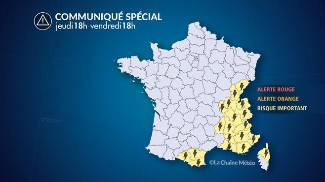
Thunderstorms break out from the Ariège Pyrenees to the Centre-East and South-East regions in the night from Thursday to Friday, says the Weather Channel *. The cold front continues to advance eastward this Friday.
Since Thursday afternoon, thunderstorms have spread to all the Alps, where the strongest thunderstorms will develop. The Corsican mountains and the east of the Pyrenees are also affected.
This Thursday evening, thunderstorms shift from the Pyrenees to the Marseille region and from Provence to the Alps. They are locally strong in the Eastern Pyrenees and in the Aude. Water slides can cause runoff and flash flooding. There are strong gusts of wind under the most powerful thunderstorms.
Hail risk
During the night thunderstorms are sometimes violent in the Rhône Valley and in the Provence-Alpes-Côtes d'Azur region. There is a moderate risk of hail. The Northern Alps and Franche-Comté are gradually caught up by storms.
On Friday morning, the thunderstorms dissipated, but the cold front continued to advance eastward. It causes the formation of strong accumulations on the Alps, where heavy rainfall is expected. Conditions improve in the afternoon, with the lifting of the mistral and tramontana in the Mediterranean.
*The Weather Channel is owned by Le Figaro Group.